Saturday 30 January 2016

Railway Reserve Heritage Trail - Bellevue to Darlington


The Railway Reserve Heritage Trail is located in the Perth Hills. It starts from Bellevue (Shire of Mundaring) and goes up to Wooroloo- a 37 km walk. There are two routes to do so, connected at Mt Helena. The trail retraces the old Eastern Railway which linked Fremantle and York in the 1880s.

The brochure is a good guide for the distance and the level of elevation, and other facilities. You can also start your journey at different points of interest. Once you reached one, you will spot a map showing where you are, with some history behind the area. There are additional guides on the trail, showing distance yet to covered till next stop. There are some lovely scenery and spots along the trail.

On 14th of June, 2015, we started our walk from Bellevue to Darlington and back. We began at 10.30.a.m and returned by 4.00.p.m. It was a rather long journey, but it was a nice stroll along the bush and down history, especially coming across a mountain quarry. Don't we all appreciate those unexpected encounters?
As we go up the hills, we can spot Perth City. There are some beautiful plants- namely the Golden Wattle-along the way. Our first stop was in Boya, and then we continued up to Darlington.
In Darlington, we came across the old railway station, also various signposts showing where the ticket office, restroom and shed area were.  Then, there is the John Herington Memorial picnic area.

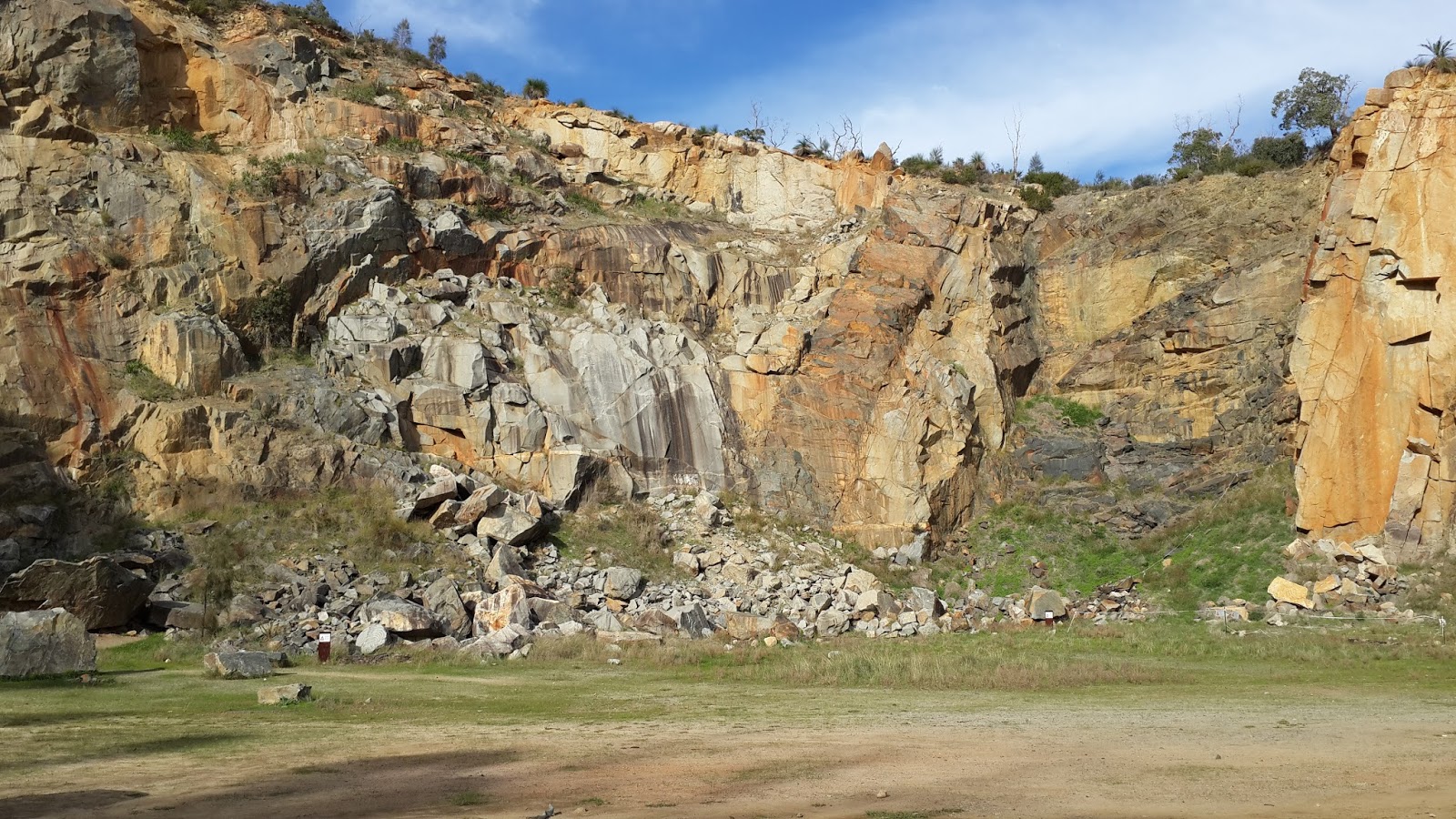
We accidentally came across a mountain quarry. It was quite impressive to look at. There were some climbers at various spots attempting to reach the top. 

The way back was lengthy, but most enjoyable.

For more information, please visit below website:
http://www.railwayreserves.com.au/Pages/home.aspx

For the heritage trail brochure, please click on below link:
http://www.railwayreserves.com.au/Documents/Railway%20Reserves%20Heritage%20Trail%20brochure.pdf

Note:
There is a parking spot at Purton Place if you want to start your journey from Bellevue.

Thursday 28 January 2016

The Perth Mint

The Perth Mint is located in East Perth and is one of WA's main tourist attraction.  It is a place where you can buy gold and learn more about gold, in general. There are hourly guided tours, which will enlighten you about the history of the gold rush in WA and broaden your knowledge about the building's heritage. 
The tour starts from outside with a talk about the discovery of the three largest nuggets found in the WA. We then head inside (no camera allowed) and are welcomed by a 1 million gold coin (both intrinsic and face value being $1 million, even though if you could sell in terms of gold, it would be worth millions). The coin is truly a masterpiece and was awarded a Guiness World Record in 2012. Be aware that at night, the revolving coin goes deep inside a vault, so there is no chance of it being stolen.
After this, you are free to roam around some gold exhibition and learn some more facts about gold. You even have the opportunity to touch and lift a real gold bar (a lucky feeling). Next, there is a pouring gold demonstration, where you will see how a gold bar is made, melted into liquid and then back to its solidified state. It was quite intriging to see how it is done. Funny fact is that the same gold  metal has been used for all the demonstrations since the show first started. 
I was personally amused by the idea that there was a weight machine, which measures your weight in terms of real time gold price. I wish I was made of gold. There is nice alfresco outside, as you finish your visit.

Overall, it was a very interesting and insightful place to visit. It is, for sure, the closest I have been to so much gold.

Please refer to below link for admission prices and opening hours:
http://www.perthmint.com.au/visit_the_mint_perth_mint_visitor_information.aspx

For more information, please refer to below link:
http://www.perthmint.com.au/


Wednesday 27 January 2016

Champion Lakes


Champion Lakes is located in the City of Armadale. It holds a 2000 metre artificial rowing course and was built in 2007. The Champion Lakes Regatta Centre has been hosting several sporting competition including rowing, kayaking and dragon boating since then. 

There is an 11 kms walk and cycle path surrounding the lake. In addition, there is an open water area for the public, as well as toilets, bbq and picnic areas across. I was personally pleasantly amazed at the pristine blue lake. It is such a delight to see such a beautiful man-made feature and undoubtedly is worth a visit.


Source:
http://www.venueswest.wa.gov.au/our-venues/champion-lakes-regatta-centre/


Tuesday 26 January 2016

Lion's Look Out, Lesmurdie


The Lion's Look Out is located in the suburb of Lesmurdie (Shire of Kalamunda), to the East of Perth.  The parking spot gives a splendid view over Perth City. There are also picnic tables and a bbq facility. 

We did the trail last year on the 25th of October. It starts from the parking site and as you go uphill, you will be amazed by a gorgeous view over City and the coastal plain. Do follow the trail, since we took the wrong direction the first time and ended up in a very steep and rocky road (please refer to the Earth mode google map). There is a loop, so if you go on the left, then you should return from the right. 
We took about an hour and a half to do the loop. It was another great place to have a walk and discover some more wildlife and wildflowers. 


For more information, please visit below website:
http://www.kalamunda.wa.gov.au/Leisure-Tourism/Sports-Fitness/Walking-Cycling/Walking-Trails/Lions-Lookout-Walk

Monday 25 January 2016

Ellis Brook Valley Reserve


Ellis Brook Valley is located in the suburb of Martin (City of Gosnells), south east of Perth City. There are four walk trails with each of them depicted by a different animal sign. The trails range from easy to difficult. These include a trail accessible to wheelchairs. There are maps and several signposts to guide you throughout. There is absolutely no chance of getting lost, that is.

Each of the trails leads to different areas and ranges from 500m to 3kms. These defiietely cater for different group of people. First, we did Sixty Foot Falls Trail up to the first lookout. As you go up the Sixty Foot Falls, you are welcomed with a spectacular view on the valley and some well-built walk paths.


We then completed the Eagle View trail, which was a steeper walk in the bushes. My advice is to wear long pants. The view from up there though was definitely worth it. Besides, it did not take us long to get to the top. You will also come across many native Australian species and plants. For instance, we came across an Australian Christmas tree.


After this, we did the Easy Walk Trail, which was a very leisurely and effortless walk. 
Overall, the trails did not proved to be that hard. However, I did use a hiking pole for the hilly parts since it can get quite rocky. I hope to complete the Sixty Foot Fall circuit some day to see the waterfall.


On the way back, we spotted some kangaroos across some pasture. This was such a delight to see so many of them. This was my third time seeing so many wild kangaroos altogether. One must be careful while driving down that road since you would not want to hurt any of those precious living beings. Well, this was a great discovery and a very nice Sunday spent. 

Note about the reserve:
-There are plenty of picnic tables and benches across the trails.
-There are bbq areas and composting toilets.
-There is no water provision, so do bring you own water supply.
-The gate closes at 5.00.p.m. There are still space to park outside though.

For more information, please refer to below link:
http://www.gosnells.wa.gov.au/About_our_City/Environment/Caring_for_our_environment/Bushland/Ellis_Brook_Valley

For the walk trail's map, please click on below link:
http://www.gosnells.wa.gov.au/files/sharedassets/public/pdfs/environment/ellis_brook_valley_pocket_map_2014.pdf

Sunday 24 January 2016

Heirisson Island

Heirisson Island is an island in the Swan River. It is located in between the suburbs of East Perth and Victoria Park. If you are going to the city from Victoria Park, you will have to go through the island. The road (Causeway) goes straight through middle of the island and separates the island in two halves.
The first time I went there was to have lunch on the island. We then decided to go for a walk, for they have some nice walking/cycling paths. We also wanted to enjoy some stunning views and scenery across the Swan River. So, we went under the bridge and started our walk on the east side of the island from the south.
The most memorable event, though, was to spot some kangaroos. It was definitely my first time encountering some wild kangaroos- two of them- and you would guess my excitement. One of the them was just laying down, unaware of everything and the other one, just hoping and looking for food, I guess.  After taking just enough photos, we followed the path, went round the lake and then made our way back to the parking spot.


It was certainly a most enjoyable day. It is an easy place to get to and it is amazing to find such a sanctuary just a few kilometres away from the city. I would highly recommend to visit this place, have a leisurely walk and see some of the wildlife in Perth. 

Saturday 23 January 2016

Bold Park


Bold Park is an urban bush land area in the North of Perth, in the suburb of City Beach. On  the one side of the road (Perry Lakes Drive), there is a park with the usual walking and cycling paths, picnic tables, BBQ areas and playgrounds. On the other side of the road, there is the reserve with several walking trails. The park itself is already a very nice area to walk, have a bbq or discover new species. When we went back in June last year, we came across some lovely kookaburra birds perching on some trees.


The reserve has several trails on its own and two entrances. There is a map on each entrance, indicating where you are and the estimated walk time. We started our walk at around 1:30.p.m., just after lunch from the Tuart Car Park. We then walked across the Zamia Trail. As we walked up the slope, we could perfectly see the city from behind. There are also signposts along the trails, so you will not get lost. 


We then went the Reabold Hill which provides a spectacular view on the city and on the Indian Ocean. There are even maps which depicts how the area looked years ago. From there, we could spot Rottnest Island and Fremantle.


After that, we return to the Zamia Trail, took the Thornbill Walk and went through Yoorn Walk to reach the Camel Lake Car Park. On the Yoorn Walk, there is a Camel Lake Heritage Trail which you can also do. We finished our walked by 3:30.p.m. This was a really lovely and leisurely walk.


For more information, please refer to the below website:
http://www.bgpa.wa.gov.au/bold-park